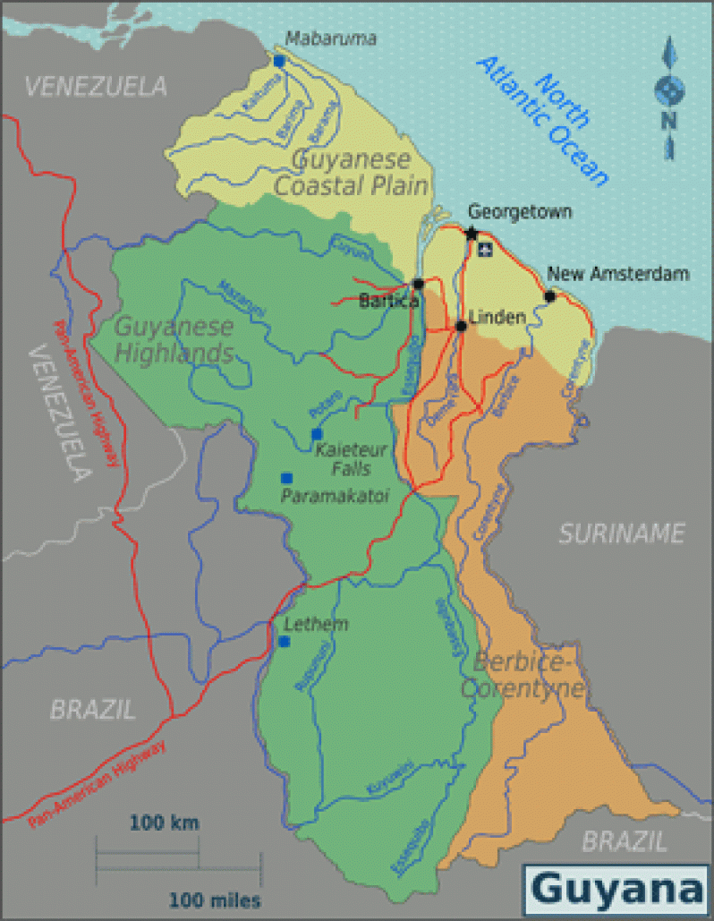
Northern Province: The Low Coastal Plain
SAND and shell reefs close to the Coast and in parallel belts, which can be found miles inland, are a conspicuous geological feature of the Low Coastal Plain. The Low Coastal Plain, along the Atlantic Coast, extends from the border with Suriname, in the east, to the border with Venezuela, in the northwest.
The Plain is made up of marine alluvium (mud and silt deposited by the Atlantic Ocean) interrupted in a few places in the North West District by low hills of decomposed rocks, as for instance, the Aruka and Santa Rosa hills.
It extends to distances ranging from five miles to, and in some places thirty-five miles from the coastline, and occupies about six per cent of the total of Guyana’s landmass.
About two metres below sea level, the Low Coastal Plain is home to more than 90 per cent of the country’s population. It is also the area where most of the administrative, agricultural, industrial and residential activities are concentrated.
The formation of the Low Coastal Plain began during the rising of the Atlantic Ocean during the Cretaceous period (seventy million years ago). As the Ocean rose, it deposited mud and silt on the coastland. The coastland built up and the Atlantic retreated.
The sand and shell reefs, which are conspicuous in many rural areas along the Coast, mark the former beaches of the Atlantic Ocean of thousands of years ago.
These sand and shell reefs, running in parallel belts at varying distances from each other, can be found in some rural coastal areas as far as six miles inland.
In some coastal villages, where these reefs are very visible, they are given names such as First Reef, Second Reef, Third Reef etc., depending on their distance inland. Sand and shell reefs have been reported at Moruca and Waini, in the North West District, Region One (Barima/Waini).
In 1976, teams from the Geological Survey Department began a detailed survey of shell and sand reefs along Guyana’s coastlands. It was believed that the shells, when processed, would produce limestone, a soil conditioner which assists in the control of soil acidity, and also quicklime, a major component for cement manufacture.
The surveys were concentrated in the Demerara-Corentyne areas, and took the teams, in some cases, as far as four miles inland where famers had indicated that they had seen sand and shell reefs, particularly in the vicinity of Victoria and Hope in Region Four (Mahaica/Berbice).
Information on the outcome of these surveys has proven difficult to obtain. At the same time, large rivers which were formed, for example the Amazon, also brought huge deposits of silt from the interior of the South American continent and dumped them into the ocean.
The alluvial mud, swept out to sea by the Amazon River, was brought north by ocean currents, and deposited on Guyana’s shores, adding to the formation of the Low Coastal Plain and continuing to do so, even now.
The alluvial deposits, of which the coastal plain is comprised, are of considerable thickness in some places, reaching up to two hundred feet in thickness. The deposits rest upon beds of pipe-clay or of laterite. Some parts of the Coastal Plain also contain considerable quantities of decomposing vegetable debris at various depths.
There have been occasions when large quantities of flammable gas, derived from the breakdown of these underground debris, are encountered during the drilling of potable water wells. There have been quite a few instances in which this gas has been captured and put to use as cooking gas, such as on the island of Wakenaam.
A lesser known but remarkable feature in parts of the Low Coastal Plain is the occurrence of extensive beds of peat, locally known as pegasse. These beds are really an accumulation of partially decayed vegetation matter, such as the remains of ferns, mosses, sedges and other swamp-loving plants. The pegasse is spongy underfoot if not deep.
There are areas where one can sink to one’s knees or even deeper when walking through these bogs of pegasse.
The Hilly Sand and Clay Belt
A line of swamps form a barrier between the white sandy hills of the Hilly Sand and Clay Belt and the Coastal Plain.
These swamps were formed when water was prevented from flowing onto coastal croplands by a series of dams to serve as reservoirs during periods of drought. The Belt consists of low sandy hills interspersed with rocky outcrops, and supports dense hardwood forests.
The white sand and clays were formed from the erosion of bedrock (consolidated rock underlying the surface) over thousands of years.
The Belt, about 150 to 250 kilometers wide, takes up about 25% of the total area of the country, and is known for its large reserves of bauxite.
NEXT WEEK: The Northern Province Cont/d


.jpg)


