.jpg)


Geologic provinces
IF YOU were able to get a special flying machine with a sophisticated computer and with X-ray lens that could penetrate the dense canopy of the forest; and if you were to fly from the tip of Guyana right down to the bottom, you would see three different landscapes. As you commence your flight from the north, you would soon put the low Coastal Plain and Hilly Sand and Clay Belt behind you, and encounter the landscape of the Greenstone Belts.
As you move southwards, you would see the weirdly jumbled up Kaieteurian Plateaus, the majestic falls and, to the
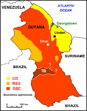 |
| LEGEND Coastal Deposits (CD) (Cretaceous – Recent) Rocks of the Takutu Basin (TB) (Jurassic – Cretaceous) Rocks of the Guiana Shield Complex (GSC); includes the Roraima Supergroup (RSG) (Precambrian) Linden … Bauxite Mine Omai ….. Gold Mine |
southwest, Mount Roraima. Next in view in your X-ray would be a huge gash in the earth, like a massive wound, indicating the presence of a graben (German word for ditch) or rift valley.
With the rift valley in your rear view mirror, you soon see more mountains ahead; but if you put the ‘age dating for rocks’ on your computer, you would find a startling difference — the rocks here are 1.3 billion years older than the ones you had first passed in the mountains after the Coastal Plain.
If you were not shocked by this, and can manage to end your journey safely, then you can say that you have flown over the three ‘geological provinces’ of Guyana, namely: The Northern Province, the Takutu Graben, and the Southern Province.
A geological province is defined as “any large area or region, all parts of which are characterized by similar geological features, or by a history differing significantly from that of adjacent areas.”
The Northern Province
The surface features of the Northern Province of Guyana comprise the Low Coastal Plain, the Greenstone Belts, and the Kaieteurian Plateaus and mountains of the Roraima Super Group.
This province begins from the Low Coastal Plain and extends southwards to the edge of the Takutu Basin, encompassing Administrative Regions One, Two, Three, Four, and Five, and parts of Regions Six, Seven and Eight.
The Low Coastal Plain comprises deposits of marine clays and white sand from the Cretaceous Period (seventy million years ago) to the recent time period (Late Cretaceous to recent on the geologic time scale).
The three Greenstone Belts cut across northern Guyana in a general southeast-northwest direction, underlying the layers of white or red sand of varying depths. They are collectively known as the Barama-Mazaruni Super-group.
From north to south, they are the Greenstone Belts of the Barama Group, of the Cuyuni Group, and of the Mazaruni Group. The Greenstone Belts underlie Regions One (Barima/Waini), Region Seven (Cuyuni/Mazaruni) and Region Eight (Potaro/Siparuni).
The belts are wide bands of fresh to weathered meta-volcanic rocks (rocks formed from lava) alternating with sedimentary rocks covered by soil layers of white or red sand.
The Barama Group (Region One) is composed of a series of ultramafics, hornblende-bearing porphyry intrusions; meta-volcanic rock types characteristic of rocks derived from deep in the interior of the earth; and meta-conglomerates (rocks that are changed in composition by weathering and other deformation processes).
At the base of the Cuyuni Group (Region Seven), there are similar ultramafic and meta-mafic volcanic rocks.
The central part of the Cuyuni Group is dominated by andesitic and subordinate felsic flows and volcanic tuffs, and the upper part of the group is dominated by metasediments and conglomerate locally, with an unconformable contact with the underlying mafic volcanic rocks.
The Mazaruni Group is the best exposed of the three Greenstone Belts. It consists of the Issineru Formation, which is predominantly meta-basalt with layers of dolerite or gabbro, tuffs and andesite, and the Haimaraka Formation, which is predominantly meta-sediments with andesite volcanics and conglomerate layers.
There are other smaller Greenstone belts to the north and south in the Mabaruma (Region One) and Wenamu (Region Seven) areas. There are also isolated exposures of Greenstone Belt rocks in the southern margin of the Berbice Basin.
The Barama, Cuyuni and Mazaruni Greenstone Belts were formed in the Lower Proterozoic period, and are surrounded and intruded by numerous granite bodies of Trans-Amazonian age, ie: 2-2.3 billion years ago.
NEXT WEEK: Geology of Guyana’s Northern Province cont/d