

.jpg)


IN a bold leap toward modernisation and sustainable development, Guyana is on the brink of completing a revolutionary digital transformation in land management, ushering in a new era of efficiency, accuracy, and accessibility.
At the heart of this national advancement is the Sustainable Land Development and Management (SLDM) project, a collaborative initiative led by the Guyana Lands and Surveys Commission (GLSC), in partnership with the Food and Agriculture Organization of the United Nations (FAO) and funded by the Guyana REDD+ Investment Fund (GRIF).
From updated infrastructure and cutting-edge technology to human capital development and sustainable land use practices, the transformation redefines how land is surveyed, administered, and managed—positioning Guyana as a global leader in digital geospatial innovation.
At the physical core of this transformation lies a robust expansion of GLSC’s regional presence. New offices have been constructed in Black Bush Polder, Bartica, and Port Kaituma, complementing recent buildings in Crane and New Amsterdam. For communities long underserved by centralised land administration systems, these modern offices—with staff housing included in Bartica, Port Kaituma, and a renovated facility in Mabaruma—bring critical services closer to home.
These regional hubs now allow residents and businesses across Guyana to access essential land services—ranging from residential and agricultural leases to support for eco-tourism, commercial ventures, and infrastructure development.
The project’s technological integration is arguably its most transformative dimension. A suite of state-of-the-art tools and systems is accelerating survey work, enhancing accuracy, and enabling a seamless digital experience for both staff and users.
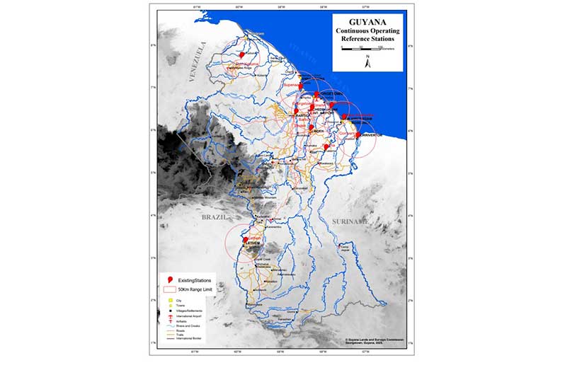
Key highlights include: Modern Survey Equipment: The national Continuously Operating Reference Stations (CORS) network has expanded from 8 (mostly non-functional in 2020) to 11 active stations. This provides centimetre-level accuracy, allowing surveys to be completed in hours instead of weeks; GNSS and Total Stations: These devices, paired with new field-to-office workflows, have streamlined survey processing, vastly improving turnaround time; LIDAR and Aerial Mapping: High-resolution, airborne surveys now cover Georgetown, Linden, Lethem, Bartica, Mahdia, and rural areas in Regions 3, 4, 5, and 6. For the first time in over 40 years, Guyana’s topographic maps are being fully updated; Digital Survey Plan Management: The digitisation of over 90,000 survey plans—once trapped in physical bin cards—now allows instant access through an online index. This removes the need for time-consuming, in-person file searches; Enterprise GIS Infrastructure: A hybrid system built on ESRI ArcGIS and open-source platforms supports integrated spatial analysis and data-sharing across agencies; and 3D Laser Scanning: A recently acquired Leica scanner enables high-definition 3D mapping—vital for engineering, public safety, disaster recovery, and even historic preservation.
Behind every piece of technology is a team of trained professionals driving meaningful change, and the SLDM project has made significant investments in training, upskilling, and academic collaboration to ensure long-term impact.
Through partnerships with the University of Guyana, new programmes in land administration, valuation, and spatial science have been introduced or proposed to strengthen the country’s professional base.
Technical staff have received in-depth instruction in Global Navigation Satellite Systems (GNSS), Total Station operations, and survey software, while inter-agency training has supported capacity-building across institutions such as the Geology and Mines Commission, Forestry Commission, and Housing Authority. Additionally, GLSC’s participation in major international conferences has exposed staff to global best practices and cutting-edge innovations, enabling them to align Guyana’s land management systems with internationally recognised standards.
As a direct result of this transformation, the GLSC has dramatically improved its responsiveness to national projects. From housing schemes and power lines to schools, hospitals, and roads, land-related surveys and permissions are now completed faster, helping unlock national and regional development.
High-precision GNSS tools ensure long-term accuracy and reliability in land boundaries, while digital survey records minimise disputes and administrative delays. Since 2020, the Commission has recorded a historic surge in land applications—thanks in large part to its upgraded systems.
Perhaps the most groundbreaking advancement has been in geodetic surveying—the science of measuring and understanding the Earth’s geometric shape and gravitational field.
Guyana has developed its own Geoid model, a complex mathematical tool used to measure elevation in relation to sea level. This model, based on the Georgetown Datum (GD), provides a consistent baseline for vertical measurement—crucial for everything from infrastructure to flood risk management.
Moreover, Guyana’s integration into the South American SIRGAS network and adoption of a new national coordinate reference system, aligned with the globally recognised WGS 84, fulfills the UN’s call for a Global Geodetic Reference Framework.
The SLDM project is also laying the groundwork for a next-generation Lease Management System (LMS). This fully digital platform—currently in pilot phase—aims to manage all aspects of land leasing, including applications, approvals, survey data, and lease records.
Built to ISO standards and aligned with the Land Administration Domain Model (LADM), the LMS will provide a single, integrated interface for all land-related data. This promises transparency, speed, and accountability across all government land transactions.
In alignment with Guyana’s role in the UN Convention to Combat Desertification (UNCCD), the SLDM project also focuses on environmental restoration and sustainable agriculture.
Pilot initiatives in Regions Four, Seven, and 10 are repurposing mined-out lands through shade house farming, vetiver grass planting, and dragon fruit cultivation. These efforts are supported by organic practices like vermicomposting and biochar use, aimed at restoring soil health and boosting productivity.
Dr. Gillian Smith, FAO’s Representative in Guyana, summarised the significance of the transformation:
“I am extremely pleased with the remarkable progress of this project, which is not only transforming how land is managed in Guyana but also positioning the country at the forefront of global advancements in technology for a sustainable future.”
As Guyana’s economy continues to expand, the transformation of its land management systems through the SLDM project is both timely and visionary. From mapping and leasing to restoration
and development, Guyana now boasts a digitally integrated, globally aligned framework that ensures land remains a cornerstone of prosperity and sustainability.
Through precise, efficient, and tech-powered land governance, Guyana is not just managing land, it is reimagining its future on it.


