The Kanuku Horst: Nucleus of the Guiana Shield
THE Southern province of Guyana is the third and final geologic province to be explored by Earth Matters. The term ‘geologic province’ is defined as “any large area or region all parts of which are characterized by similar geological features, or by a history differing significantly from that of adjacent areas”.
Old Guyana
The Southern Province comprises the Kanuku Mountains and the South Rupununi Savannahs. Being part of the Kanuku Complex, the South Rupununi Savannahs are geologically very distinct from the North Savannahs.
The Southern Province is bound in the north by the Takutu Graben, and in the south by the Guyana/Brazil border. This Province is the nucleus or central part of the Guiana Shield, and is presented as an “Old Crystalline Basement” and the Proto-Kanuku (Early Kanuku) Complex. It is indisputably the oldest part of Guyana.
According to information obtained from the Guyana Geology and Mines Commission (GGMC), the Proto-Kanuku Complex dates between 3.1-3.4 billion years of age Ga, but independent sources dispute this.
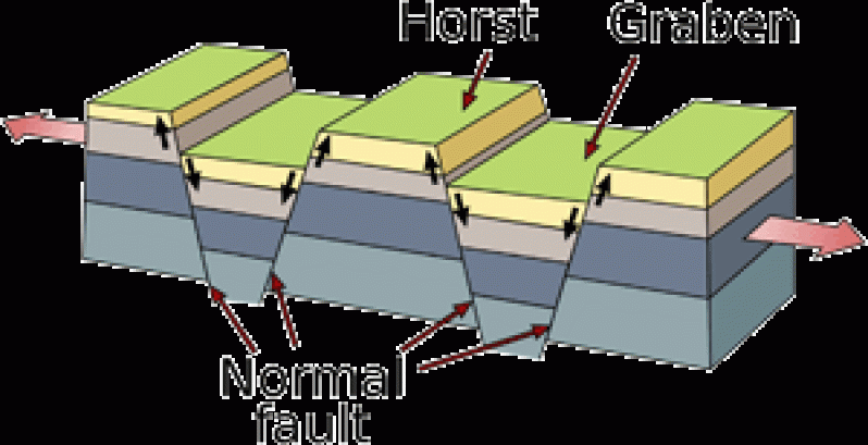
The Kanuku Mountains are also called the Kanuku Horst, the mountains having appeared as a result of block faults which lowered the Takutu Graben during the Late Triassic to Early Jurassic periods, between 200 million and one hundred and fifty million years ago. In physical geography and geology, a horst (German for ‘heap’) is a raised block of terrain bound by normal faults or rift valleys. A horst is formed from extension of the Earth’s crust through the divergent movement of tectonic plates. The raised block (horst) is a portion of the crust that generally remains stationary, or is uplifted while the land has dropped on either side. Thus, horsts are the opposites of grabens.
The graben is the down-dropped block, and the horst, eg: the Kanuku Horst, is an upthrown block that lies within the centre of the graben/rift valley. The Kanuku Horst divides the Rupununi Savannahs, which extend into Brazil, into a northern and southern section, and accounts for about 1,750 square miles of area.
The horst is part of an east-northeast trending mobile belt known as the Central Guyana Granulite Belt, which extends into Suriname to the east and Brazil to the west, GGMC sources have said.
The Kanuku Complex is made up of metamorphic rocks mixed with igneous granite and dolerite intrusions, dolerite being a volcanic rock which was involved in the Imataca Thermo-tectonic event /orogeny around 2.77 Ga.
Between 2.77 Ga and 2.4 Ga, Southern Guyana experienced shallow marine sedimentation and basaltic intrusions (intrusions of magma) through volcanoes which form what is called the Kwitaro Group.
The Trans-Amazonian Tectonic event of 2.4 Ga gave rise to granitoid rocks (commonly known as the Younger Granites) not only in the Southern Complex, but in the Essequibo-Corentyne and in the Konashen (Deep South Rupununi) adamellite granitic intrusion.
Gneisses (metamorphosed granite) in the Kanuku Complex were formed during a reactivation of the Trans-Amazonian event at approximately 1.8 Ga. This reactivation, marked by the emplacement of the Kuyuwini Group of rocks (far of South Guyana) and Burro-Burro Group of rocks (north of the North Savannas Rift Valley), it was said, signified the end of the major geologically transformative Trans-Amazonian event.
The name Kanuku means ‘forest’ in the Wapishana language, a reference to the rich diversity of wildlife found there.
The Eastern Kanuku Mountains and the Western Kanuku Mountains are separated by the Rupununi River.
The lowland forests of the Kanuku sustain 60% of all the known bird species in Guyana. 150 mammal species, or 80% of all mammals found in Guyana, live in the Kanuku Mountains. Prominent species include the Giant Otter, the Harpy Eagle and the Arapaima fish.
In October last year, then President Bharat Jagdeo approved of the designation of the Kanuku Mountains as a protected area, in keeping with legislation enacted in Parliament. A protected area is a location which is important for its landscape, beauty or biological diversity or “biodiversity”, to the extent that its features should be protected by national law.
Prior to the President’s declaration, Guyana had only three legally protected areas, namely Kaieteur National Park, Iwokrama International Centre for Rainforest Conservation and Development, and The Konashen District Community-Owned Conservation Area.
As in these areas, also including Shell Beach, activities such as hunting, removing animals, picking or damaging flora, mining or commercial harvesting of timber are prohibited by law.
The Kanuku Mountains/Horst rise to almost 3,000 feet above sea level.
Earth matters…
SHARE THIS ARTICLE :
Facebook
Twitter
WhatsApp


