


.jpg)


The Takutu Graben
GUYANA is geologically divided into three provinces: The Northern Province; the Southern Province; and, between them, the Takutu Graben, or Takutu Rift Valley. 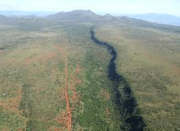 Earth Matters has, to date, provided information on the Northern Province, comprising the granite greenstone belts and the Roraima Group of sedimentary rocks.
This article provides information on the province in between the Northern and Southern Provinces: The Takutu Graben.
What’s a graben?
By definition, a graben is a linear-shaped lowland between highlands or mountain ranges. It is created by the action of a geologic rift and faulting. Also called a rift valley, a graben is a down-dropped block of the earth’s crust, resulting from its extension or pulling apart.
The down-dropped block of the earth has taken place at a point of divergent activities of tectonic plates. Two plates pulling away from each other, stretching as if to rip themselves apart, have caused the surface of the earth to crack in a process known as rifting. The earth’s crust stretches, fractures, and sinks as it is pulled apart.
When the tensional forces are strong enough to cause the crust to crack, it does in such a manner that a centre block will drop down relative to its flanking blocks, forming a graben, a German word meaning ditch.
Grabens are, in effect, the subsidence of the land between two normal faults/cracks in the earth’s crust. As this process continues over tremendous amounts of time, the valley gets wider and wider, until it becomes a large basin that fills with sediments from the rift walls and the surrounding area. Grabens can be hundreds of kilometres in length.
Some well known graben valleys are the Red Sea Basin, the Alamosa Valley of Colorado, and the Graben of East Africa and the rift valleys of Kenya.
The Takutu Graben
Guyana’s Takutu Graben is bounded by the Pakaraima Mountains in the north and by the Kanuku Mountains in the south. It is popularly known as the North Rupununi Savannah Basin. Population centres in the valley include Wowetta, Annai, Aranaputa, Yakarinta and Lethem.
The Takutu Graben is also referred to as the Takutu Basin. This Takutu Graben/Basin is 280km long; up to 50km wide, and over 7km deep. It extends for 180 kilometres (km) into Brazil to the west, and covers more than 11,200 square kilometres in Guyana and Brazil.
It is also said to be part of a trans-South American fault zone which extends in an east-northeast direction from the Pacific to the Atlantic, right across the South American continent where tectonic tensions are slowly at work stretching the earth’s crust, pulling it apart. It is the main geological feature of the Northern Rupununi.
Compared to the formation of the granite-greenstone belt (2.25 billion years ago) and the Roraima formation (2.1 to 1.9 billion years ago) of the northern province, the Takutu  Graben is a relatively young geological formation.
The geologic history of the Takutu Graben is characterized by one phase of volcanic activity and three depositional phases of sedimentary rocks. Rifting (due to divergent tectonic plate movements) began to form in a lake or delta environment in the Late Triassic to Early Jurassic periods, between 200 million and one hundred and fifty million years ago; and this rifting led to volcanic activity and the extrusion of the Apoteri basaltic lava flows.
A study of the strata of the rocks in the graben, obtained by drilling and seismic work, shows that the Apoteri basalts underlie the valley in a layer about 1,700 metres thick. These volcanic basalts also outcrop along the southern and eastern margins of the graben, and include Toucan Hills in Brazil, which are 135-million-year-old hills of layers of lava flow.
Lower Jurassic non-marine sedimentary rocks of the Manari Formation overlie the eroded basalt.
These are overlaid by lower to middle Jurassic non-marine shales (fine grained rocks) of the Pirara Formation, and in turn by non-marine sedimentary rocks of the middle to upper Jurassic Takutu Formation, deposited in a lake or delta environment.
Some sediments in the Takutu Graben/Basin were deposited by the Proto-Berbice which, between 30 and 25 million years ago, emptied the Branco, Essequibo, Demerara and Berbice watersheds into the Atlantic.
Since its formation, the Takutu Graben/Basin has been filled with sediments to a depth of 5,400 metres.
In the science of geology, the terms graben, valley, basin, and even trough can be used interchangeably when produced by rifting and faulting.
Horsts
Horsts are the opposites of grabens. A horst is found together with a graben in an extensional tectonic environment. The graben is the downdropped block, and the horst, eg., the Kanuku Horst, is an upthrown block that lies within the centre of the graben/rift valley.


