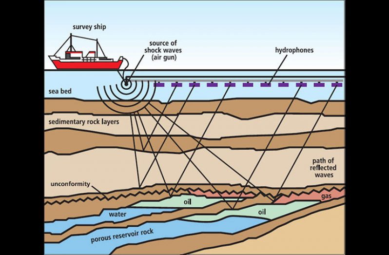
VERY soon, Guyana will better understand its offshore assets and increase its leverage in oil block negotiation, following the conduct of its own 2D and 3D seismic surveys.
Speaking with the media on Monday, Director of the Department of Energy (DE), Dr. Mark Bynoe, said that the procurement process for a firm to conduct the surveys is almost completed. In fact, several bids have already been submitted and the evaluation is completed.
“Only yesterday [Sunday] I was speaking with the procurement officer; they’re just about to make a notification. The evaluation report was completed and we are awaiting the evaluators to just sign off and then we can make a formal declaration,” he said.
Seismic surveys are conducted by creating a shock wave, also known as a seismic wave, on the surface of the ground along a predetermined line, to map subsurface formations and anomalies.
While it is most often used by exploration companies to determine the best locations for drilling, while saving on dry holes, the DE has recognized the importance of Guyana understanding its available resources offshore, to guide its future allocation.
Back in November 2019, Dr. Bynoe stated that Guyana is fairly ignorant when it comes to what potential assets are within its shallow continental shelf, for example. He said that the country will not rush into the awarding of additional oil blocks until those and other outstanding matters are finalised.
The data from the surveys will allow for more informed issuance of oil blocks, and for an upperhand during negotiations. It would set the stage for a new licencing round for offshore acreage around the second quarter of 2021, should plans remain on track.
In providing an update on the procurement process on Monday, he explained that the surveys will aid in the development of data packages which will be used to provide indications on prospectivity within a specific location. It will also help the country to be able to define boundaries of potential blocks it may wish to issue.
The contract will also incorporate the use of historical data on acreages relinquished, and a 3D seismic on Block ‘C’ to determine whether it should be kept in its original state or divided, and what potentials exist.
Block ‘C’ is Guyana’s s sole remaining ultra-deep-water block for which there is significant interest by global oil majors. However, Guyana is in no rush to allocate the Block before it gets its house in order.
“The government of Guyana takes very little risk even though we have to be concerned about what price the packages are sold at. But, once we go with a company, that company will use its own monies, based on an agreement with the government, to conduct the 2D, 3D seismic with the sale of the packages, having to be agreed upon by government,” Dr. Bynoe said.
The company has but a limited period to conduct its work after which all that data must be handed over to the Guyana Geology and Mines Commission (GGMC) as the regulator. This is to ensure that Guyana’s interest and national sovereignty are protected.


