

— in protecting Leguan from the encroaching Essequibo River
JUST over six years since a sea defence breach at Cane Garden, Leguan, caused flooding at the northern end of the island and losses of rice and cash crops, mangroves are being used as a frontline defence to prevent a recurrence.
Mangroves protect people, houses and farmlands from natural disasters such as storms, floods and tidal waves. Their trunks and branches act as barriers, helping to reduce the impact of waves, flooding and storm waves.
With the waves of the Essequibo River visiting with fury, year after year, Cane Garden became mellow and defenseless.
The small village is situated at the extreme northern end of the 18 square-mile island of Leguan, located in the delta of the Essequibo River. The island, a thriving agriculture community, is one of 365 islands in the Essequibo River, Guyana’s longest river, measuring a distance of 1010 kilometres (650 miles).
This peaceful and hospitable region of Guyana is home to less than 3000 residents and in recent years has been making efforts to stave off encroachment by the Essequibo River by building rip-rap sea defences and cultivating mangrove forests along its shorelines.
The area where the breach occurred was once a thriving mangrove forest, but with many residents at the time cooking on firesides, the forest became a reliable and easily accessible source for fuel.
Around the same time, the natural coastal cycle of the Essequibo River had changed and sand instead of mud began to accumulate in the roots of the plants, causing them to gradually die out.
The mangrove forest was a buffer against the high-tide waves, reducing the force of impact before the waves reached the earthen sea defence dam.
With the destruction of the forest due to unsustainable harvesting of trees and the work of natural elements, the area where the trees once were became prone to erosion and eventually the earthen sea defence dam at Cane Garden was left exposed.
It was just a matter of time before a breach occured, and in 2010, it happened. It was first spotted by residents who implored officials of the then Government to promptly address the problem, but their advice was not heeded.
And what was initially a 9.6-foot breach, ended up being a breach measuring 5,670 feet, requiring the construction of some 500 metres of rip-rap sea defence and a groyne field costing millions of dollars to keep the sea at bay.
Residents told the Guyana Chronicle that due to the late response of the then authorities, the breach quickly widened and the sandbags and tonne sacks used to seal it proved ineffective.
This temporary measure was effective in other areas in the Essequibo region, but with no mangrove forest in place, it could not withstand the turbulent waves that battered the earthen sea defence dam.
Farmlands in the area were inundated and had to be abandoned for close to a year– in some cases longer– as authorities battled to seal the widening breach.
LOSSES
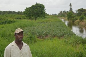
Awadh Gewan, who was forced to abandon his farm and move his cattle to higher ground,

said all his cash crops were lost on the day the raging waves breached the vulnerable and neglected mud dam.
“We complained to them before that the dam was weak, but none of them paid any serious attention, so when it [dam] break, it was not too much of a surprise. “But the problem get worse when they [authorities)] take long to respond. The breach get bigger and bigger and it was hard for them to fix in a short time. I could not farm and I eventually had to sell out my cows. Some people come around, talk with we, take down we information and promise we compensation but we never see them back,” Gewan said, as he tended his ochro plot with the help of his wife.
He said about 30 years ago, in the area where the breach occurred, there was a thriving mangrove forest, but it vanished some years ago after large deposits of sand got into the roots of the trees.
Esan Fraser, another farmer who was affected, said he could not have cultivated his 180- acre plot of land for five years, pointing out that it caused him great strain to maintain his family.
“Is only last year I restart planting and them told me that I have to pay rates for the land, even though I could not use it for five years. Them want me to pay $110,000 per year for the five year. I can’t afford that. I had to work with people to support my family and it was a real struggle. The amount they are asking for is unfair and I am hoping that they reduce it, because for five years I could not cultivate my land,” he said in a sad tone.
CUTTING OF TREES
Fraser acknowledged that heavy buildup of sand resulted in the mangroves dying out, but
pointed out that the habit of residents cutting the trees for firewood made the forest die a faster death.
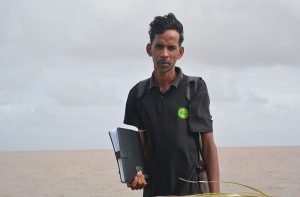
Leguan Mangrove Ranger, Donald Ramlakhan, has been actively sensitising students, farmers and residents of the 18-square kilometre island on the importance of mangroves in protecting fragile eco-systems and against erosion.
He said since the 2010 breach in the sea defence, a groyne field consisting of six groynes
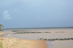
was built at Cane Garden, the northern end of the island to trap the mud washed up by the river, so as to allow for the replanting of mangroves lost in that area.
The groynes were built at a point in the village which experienced heavy erosion, but since its construction in 2012, it has been unable to accumulate the elevation of mud required to enable planting.
According to District Three (Leguan) Engineer, Seenarine Nandram, the groynes were constructed at the wrong end of the island, pointing out that where they are built will see

the accumulation of sand and not mud.
“You have to look at the sediments deposited by the river in the northern direction. They are course particles and these are not conductive for the growth of mangroves. The groynes should have instead been built on the southern end of the island, where the sediments are fine and conduce to planting of mangroves.”
DIFFERED
However, engineer attached to the Guyana Mangrove Restoration Programme (GMRP), Luandra Jack, differed, pointing out that the groynes were able to halt erosion in the area where they were built.
She also pointed out that due to natural processes, the cycle of the river changes every 20 years, and while the amount of mud has not accumulated to allow for planting of mangroves, the process has already started.
“At low tide, you can see that the mud is gradually building up; it is a process that will take time. At the southern end of the island, the river is very turbulent and if you put groynes there it might not work, because the waves would not allow for a buildup of sediments to enable planting,” Jack explained.
In an effort to restore Guyana’s coastline, the GMRP has planted some 400,000 black mangrove seedlings between 2010-2012, resulting in an additional 6.9 kilometres of coastline being protected by natural sea defence, with a buffer zone of 60-80 metres.
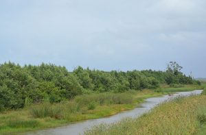
While there is no mangrove forest on shore at Cane Garden, inland, just over the mud dam, a thriving forest has regenerated naturally after being destroyed in the 2010 sea defence breach.
Underscoring the importance of mangroves, Ramlakhan said that apart from acting as a buffer against the forces of nature, they provide a habitat for biodiversity, including migratory birds and endangered species and capture carbon dioxide in their roots, stems, leaves and soil to help mitigate the effects of climate change.
It also protects Guyana’s productive coastal agricultural belt from flooding and salt water intrusion; sustain fisheries that provide jobs and contribute toward the growth of Guyana’s economy; and provide natural learning environments and recreational areas for all to explore, discover and enjoy.