


.jpg)


GIS Day is an international event celebrated annually to highlight the power and importance of Geographic Information Systems (GIS) in understanding our world. Held on the third Wednesday of November, GIS Day encourages people to learn about and engage with GIS technology, showcasing how it can address real-world challenges, from environmental protection to urban planning and disaster response.
This year’s theme, “Mapping Minds, Shaping the World”, highlights how GIS technology has revolutionised how we perceive, navigate, and shape our world. GIS Day is usually observed to promote education and awareness (introducing people to GIS and demonstrating its applications across various fields, such as environmental science, air and water management, and industrial and infrastructure management), community engagement (promoting collaboration and networking among GIS professionals, students, educators, and enthusiasts to inspire innovation and share knowledge), and to showcase real-world applications (highlighting the critical role of GIS in solving complex issues, from mapping climate change impacts to managing natural resources).
A Geographic Information System (GIS) is a powerful tool that lets us visualise scenarios and understand relationships, trends, and patterns in our environment by digitally linking information to maps. GIS is practical and valuable for presenting, manipulating, and analysing essential data, helping us make accurate and well-informed decisions. GIS plays a crucial role within the Environmental Protection Agency (EPA) by supporting environmental data collection, analysis, and visualisation. This technology empowers the Agency to monitor and manage natural resources, assess ecological risks, and enforce regulations effectively.
As a regulatory agency in environmental management, the Environmental Protection Agency of Guyana (EPA Guyana) relies on accurate and relevant data for planning, monitoring, research, and data dissemination. Geospatial data is vital to effective environmental management and is integral to the EPA’s decision-making process, significantly contributing to informed and sound decisions. The EPA Guyana continually seeks new opportunities to advance its technological capabilities and enhance the quality and credibility of its activities. The Agency envisions the ongoing growth of Geographic Information Systems (GIS) as an essential tool in today’s society. With clear policies and guidelines, well-trained personnel, and accurate, up-to-date information, the EPA aims to ensure the continuous protection and sustainability of environmental health and well-being.
At the Agency, some examples of how we utilise GIS are:
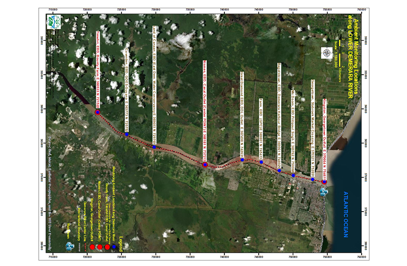
Water Quality Monitoring: Mapping river and creek areas to monitor water quality and track contamination sources to ensure safe water access.
Air Quality Tracking: Analysing air pollution sources to track pollutant spread and assess impacts on public health.
Mapping Pollution Sources: Identifying and monitoring sources of pollution, such as factories, oil refineries, and waste sites, helping agencies enforce environmental regulations and address violations.
Tracking Cleanup Efforts: Tracking cleanup campaigns, from hazardous waste disposal to derelict vehicle removal, providing spatial data to monitor progress and identify priority areas.
Real-Time Response Monitoring: The Agency can monitor real-time thermal anomalies, oil spills, and other environmental hazards. This capability allows for accurately assessing affected areas, measuring the damage extent, and effectively tracking pollution within the Exclusive Economic Zone (EEZ). Technologies used include but are not limited to MAXAR, Marine Traffic Technology, and NASA Worldview.
Regulatory Compliance and Enforcement: Enables tracking and analysing of projects for authorisation and compliance through inspection records. This helps the EPA to ensure that environmental standards are upheld.
Community Outreach and Education: Creating story maps and interactive dashboards powered by GIS to engage with real-time environmental data, enhancing awareness and encouraging responsible actions.
Join us in celebrating GIS Day 2024 by exploring the many facets of GIS, participating in fun activities like satellite viewing, and using tools like Google Earth and Esri Story Maps. Let’s map our minds and shape a better world for future generations.
Happy GIS Day 2024!
You can share your ideas and questions by sending letters to: “Our Earth, Our Environment”, C/O Communications Department, Environmental Protection Agency, Ganges Street, Sophia, GEORGETOWN, or email us at: communications@epaguyana.org. Follow us on Facebook and Instagram, and subscribe to our YouTube channel.


