

.jpg)


“THE world is getting smaller”; this statement holds true, with technological advancement, we are now able to chat with our families and friends in real-time across continents. More so, we can use Google Earth to take a virtual tour of any country on the Earth without having to leave the comforts of our living rooms. The advancement in technology is making the world more connected and more accessible. One such technology is the Geographic Information System (GIS); this technology can do numerous things such as help citizens predict areas of flooding and map soil quality to ensure efficient land use.
But what exactly is GIS?
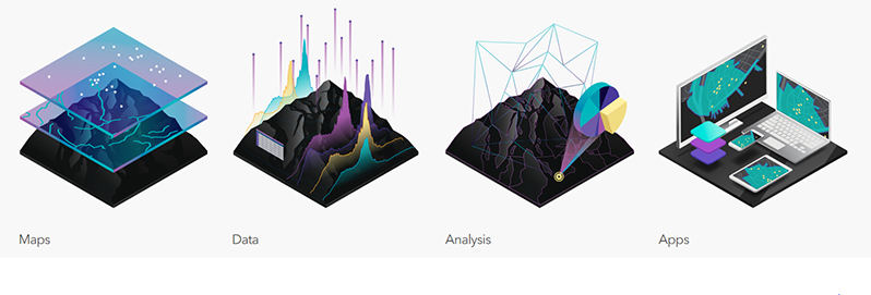
A Geographic Information System is a framework for gathering, managing, and analyzing data. Rooted in the science of geography, GIS integrates many types of data. It analyses spatial location and organises layers of information into visualizations using maps and 3D scenes. With this unique capability, GIS reveals deeper insights into data, such as patterns, relationships, and situations – helping users make smarter decisions. Further, GIS allows for people to view data as maps, rather than columns of numbers; making it easier to read and understand.
How Is GIS Data Collected?
* Digitising (the process of tracing GIS data directly on the screen)
* LiDAR (images)
* Drones
* Global Positioning System (EPA primarily utilizes this format)
* Satellites (remote sensing)
Why Is GIS Important?
* Informs decision-making
* Provides accurate data location
* Increase efficiencies
* Can reduce the cost of services
* Coherent management of resources
* Improves communication
* Vital for accurate record-keeping
Types Of Datasets Captured Through GIS Technology
* Land cover
* Climate
* Ecosystems
* Energy
* Infrastructure
* Marine resources
* Biodiversity
* Research
* Health
* Demographics
* Manufacturing/Industries
* Education

GIS in environment and natural resources management
GIS helps in identifying the impact of human behaviour on natural resources and leads to the more effective utilisation of the same. Data about natural resources could be collected through remote sensing, aerial photography or satellite imagery and then they are mapped using GIS technology. The major application of GIS in natural resource management is in confronting environmental issues such as floods, landslides, soil erosions, droughts, earthquakes, etc. It also addresses the current problems of climate change, habitat loss, population growth, pollution etc. and provides information about land area change between periods. The information obtained from GIS helps to study specific areas and monitoring can be done in and around those areas. It provides relevant information about the environmental condition and policy, including conservation programmes. Maps in GIS provide information about location and current resources.
Along with the aforementioned applications, GIS can effectively aid in wastewater management, oil spilling, sewage treatment etc. Hundreds of thousands of organisations in virtually every field are using GIS to make maps that communicate, perform analyses, share information, and solve complex problems around the world. This is changing the way the world works. At the EPA we place a high value on evidence-based decision-making and use GIS as one of the tools in the process. Our officers in the GIS Unit collect and analyse data that include, but are not limited to:
* Complaints hotspot mapping;
* Environmental inspections;
* Biodiversity research conducted;
* Water-sampling locations;
* Disease outbreaks;
* Oil wells and drill sites;
* Identifying potential and suitable landfill sites; and
* Mapping coastal changes and trends.
GIS Day – Discovering the world through GIS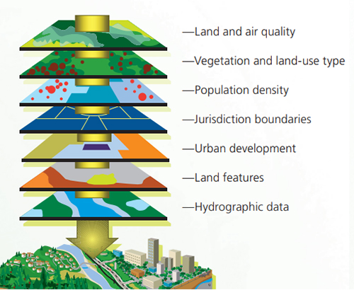
The third Wednesday of November each year is designated internationally as “GIS Day.” On this day, users of Geographic Information Systems (GIS) celebrate the technology and its multiple applications in the real world. The recognition of this day was initiated on November 1 9, 1999, by the combined efforts of the National Geographic Society, Association of American Geographers (AAG) and Esri, one of the leading GIS service providers. If you’re interested in learning more about GIS Day, then check out this website https://www.gisday.com/en-us/resources
HAPPY WORLD GIS DAY IN ADVANCE FROM THE MANAGEMENT AND STAFF OF EPA!
You can share your ideas and questions by sending letters to: “Our Earth, Our Environment”, C/O Communications Department, Environmental Protection Agency, Ganges Street, Sophia, GEORGETOWN, or email us at: eit.epaguyana@gmail.com, follow us on Facebook and Instagram, and subscribe to our YouTube channel.


