


.jpg)


THE key to effective governance is the complete dedication to the service of its people. Otherwise, how can the people reap all the benefits of citizenship?
In this edition of Government in Action, Commissioner and Chief Executive Officer of the Guyana Lands and Surveys Commission (GLSC), Mr. Trevor Benn, talks about the steps that the Commission has taken to better serve the people by increasing their access to land and by protecting the land.
SUSTAINABLE LAND MANAGEMENT
“The Sustainable Land Management project is designed to help… transform the Guyana Lands and Surveys Commission… into a more modern organisation. It is our hope that by the end of this project, we could have an updated Land Information System that allows for our clients to be able to access real-time information about their individual transaction. By the end of this project, we hope that we will have a more modern interface for the way we do business with members of the public, and it is our hope that we can bring down the time that people wait for these individual transactions,” Mr. Benn said.
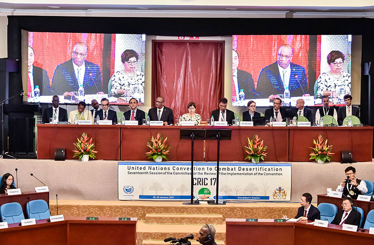
The project is in its first year of implementation, but the Commission has already sought consultations on land policy issues, geospatial policy issues, and has completed a draft policy for geospatial information. Perhaps the most notable achievement to date is Guyana’s hosting of the Committee for the Review of the Implementation of the Convention (CRIC) Conference, a convergence of global land experts.
“Our major focus is updating our capacity to serve the Guyanese public in real time, to be able to respond to requests for land, to open up new areas, to be able to have our databases updated to allow for geospatial information, [and] to be available to set up coordination information across geospatial agencies,” he said.
Commissioner Benn also outlined the numerous ways Guyana stands to benefit from the successful implementation of this project.
“People can come to the office at the Guyana Lands and Surveys Commission, at any one of our regional offices and access real-time information about land availability. We can reduce the amount of time that people take to receive a house lot or an agriculture lot,” he said.
Mr. Benn noted that real-time knowledge of the nature of land spaces will ensure that landowners receive the highest quality land for building or industry purposes.
“We [will] be able to tell the farmers, ‘this is a good rice producing area… as against sugar’ … and students doing research, geography or contractors, who want to know what the soil type is before constructing a building should be able to come and get that information. The Ministry of Public Health should be able to get… a map [that] shows the hot spots for measles … or the hot spots for water-borne diseases. We should be able to do that on a map for them across the country. The Ministry of Education – we should be able to say this is where your schools are located on the map of Guyana and how to get to those schools… This is where we are heading with Lands and Surveys so that this [office] could be a one-stop shop,” he said.
The Commission, Mr. Benn said, remains in the service of all Guyanese. “The Guyana Lands and Surveys Commission is a non-political organisation that has the responsibility as a technical service agency to all Guyanese. The service we provide here does not have a face…so, every Guyanese, any Guyanese, requiring the service can come to this office… We have tried our best to make sure that everyone who comes through the door at Lands and Surveys has fair and equal treatment… It is our obligation, once you approach us, to assist as best as we can. The staff at the Commission has been so advised… Regardless of who comes to the Commission, they must be facilitated,” he said.
A LESSON IN PREVENTION
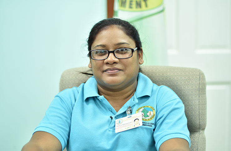
Land degradation occurs when land is negatively affected by human or natural disasters. Although prone to flooding, Guyana is relatively low risk for land degradation but Head of the Land Policy Planning and Projects Division, Ms. Andrea Mohammed, does not take this status for granted, instead, she says, the Commission stays on the front lines of prevention.
“The principle of prevention is better than fixing the problem after it has occurred… Guyana wants to be in a state of preparedness and we do not want to have to go through some of the issues that other countries… in terms of the cost of land degradation and the cost of reclamation… We want to have policies in place… We want to [build the capacity] of the Guyana Lands and Surveys Commission and our stakeholders to ensure that we do not go through some of the impacts of land degradation which affect livelihoods. It affects investments. Land is very important. It provides our food, where we live, areas for investors. We do not want to [disrupt] that,” she said.
This effort is bolstered by a thorough Land Use Policy, currently being drafted by the Commission, which will ensure that updated and timely information is being provided to all stakeholders. This, Ms. Mohammed said, paired with up-to-date mapping, provides response personnel with essential information in the event of a natural disaster.
“As soon as an area is affected… the mapping is supposed to be so updated that whoever is responding should be able to go directly to the targeted area that is affected… Having updated maps and detailed maps mean that extension officers [can] quickly go to their computers, access these maps, and know directly where to go… So having a very good database… and having it linked to the maps means that we can have very quick access to address a situation,” she said.
Ms. Mohammed further explained that having updated maps would allow stakeholders, to determine who, or what is affected during an emergency and to what extent. “Having updated maps, with all of this information, means that you would be able to assess the kind of response needed. You would know who the stakeholders are, who should be there, and what kind of actions are required for disaster response… We would have knowledge information of whom and what is being affected,” he said.
PROTECTING OUR PATRIMONY
In January 2018, Guyana signed on to the four-year $15 million Sustainable Land Management Development Plan, financed by the Guyana REDD+ Investment Fund (GRIF). Minister of Finance, Mr. Winston Jordan, who attended the signing ceremony, said that the project, once implemented, will be a guiding light in the sustainable use of Guyana’s Land.
“The overarching goal of sustainable land management should be to contribute to Government projects and programmes that are aimed at achieving poverty reduction [and] economic growth while promoting the full utilisation of land resources in a sustainable manner. As such, issues that have to do with improving land tenure security, enhancing the efficiency, transparency and improving service delivery and enhancing local government capacity to undertake land management functions must be all brought [under one umbrella]. I am happy that this project has been designed to tackle many of these areas. We have high expectations that this land management project will provide the required data to inform our planning processes and help us to position strategically our physical infrastructure such as roads, bridges, drains, culverts and other structures in order to avoid disrupting the ecosystem,” Minister Jordan said.
President David Granger, recognising the power and potential of Guyana’s land capital, said that Guyana is committed to its sustainable management.
“Reckless use and management of land can impact adversely on the environment and citizens’ quality of life. Land degradation has the potential to affect food security, sustainable livelihoods, poverty reduction and social stability. Guyana, therefore, recognises the importance of protecting its land assets. It knows that land degradation will result in natural resource depletion which, if not controlled, will lead to underdevelopment. Guyana has committed itself to preserve its land assets,” he said.
The Head of State added, “We shall also promote more efficient mining and logging practices, including post-extractive land reclamation; push sustainable forestry practices including reduced-impact logging and improved forest monitoring and pursue mineral mapping so [as] to identify areas of marginal, or less than viable, mineral deposits. These are some of the steps at the international level to which Guyana has agreed in order to protect its patrimony and in order to provide environmental services to the rest of humanity.”
The Government of Guyana continues to protect the integrity of this great resource while ensuring that all of Guyana’s children have access to her land and her natural patrimony.


