By the WWF Guyana Office
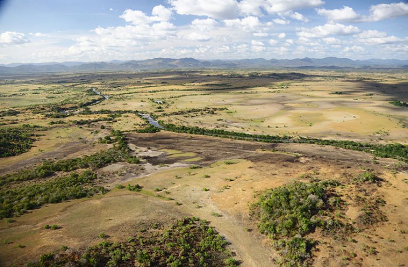
THE RUPUNUNI is sometimes perceived – especially when compared to the verdant growth of the rainforest that surrounds it- as an empty place with no function or utility. Given that much of the Rupununi is flat and open, cloaked only in grasses and herbs, with occasional small trees and woody shrubs, it looks like an obvious and easy place to convert to large-scale industrial agriculture. Periodically, the Rupununi is promoted as an agricultural gem, just waiting to be polished into an agricultural production area to match Berbice or the Essequibo Islands.
The indigenous people who live in the Rupununi know better.
Most indigenous farms are planted in fields cleared along the Rupununi’s forested edges or bush islands because the savannah soils are too poor for most crops. The National Land Use Plan of Guyana classifies over 95% of the Rupununi’s soils as ‘non-agricultural land’, ‘poor agricultural land’, or ‘poor agricultural land (fertilizing possible)’. Most of the last, ‘poor agricultural land (fertilizing possible)’, is in the Rupununi’s floodplain, and inundated during the rainy season.
In fact, the Rupununi’s cultural and biodiversity values make it among Guyana’s richest and most interesting regions. The Rupununi is one of Guyana’s most unique and diverse ecosystems, and contains the rarest ecosystem in Amazonia, Guianan Savannah, of which the Rupununi Savannah is the world’s largest surviving example.
The Rupununi is home to tens of thousands of species of plants, animals, and invertebrates, including many that are globally endangered. It is one of the most biodiverse areas in South America, providing habitat for 80% of Guyana’s birds, 86% of mammals, and 60% of fish. All these organisms are adapted to the Rupununi’s challenging climatic regime: infertile soils and the cycle of excessive water and drought.
The Rupununi’s high ecological value can in part be attributed to its interface between the Amazon Basin and Guiana Shield ecoregions. For instance, the Arapaima (Arapaima sp.), the world’s largest scaled freshwater fish, is otherwise restricted to Amazon River tributaries. The Essequibo is the only Guianan river system where Arapaima occur, because it was able to cross from one river system to the other via the flooded North Rupununi wetlands portal.
This great species richness is also partially due to habitat diversity. Despite being referred to in whole as the Rupununi Savannah, it is not only open grasslands, but includes bush-islands (isolated forest patches most often on hummocks or raised areas), lakes, creeks, rivers, gallery forests along watercourses, lowland forests and rocky outcrops.
This expansive landscape – particularly in the North Rupununi – undergoes a remarkable transformation during the rainy season: the Rupununi River and its tributaries overflow their banks, forming vast wetlands and a vital source of life for the Rupununi’s wildlife and indigenous people. The North Rupununi wetlands are a critical food source, spawning ground, nursery and migratory path for the region’s fish. The rivers and surrounding flooded savannahs are major spawning and nursery areas for fish from the Essequibo drainage. Additionally, the flooded savannahs also provide a major food source for fish during rainy season dispersals and are the basis for a food chain that feeds and sustains the region’s people and nature.
The region also supports many plant species of limited distribution, including the world famous Victoria Water Lily (Victoria amazonica), which is restricted to the Rupununi and Essequibo Rivers.
Aside from being critical for species, the Rupununi Savannah – which covers approximately 13,000 km2 (6%) of Guyana’s land area – has been home to indigenous peoples for at least 7,000 years. Today over 20,000 indigenous people, Makushi in the north, Wapishana in the south and Wai Wai in the far south, depend almost exclusively on the region’s intact ecosystems for their sustenance.
Over the past 100 years, cattle ranching provided the basis of the Rupununi’s economy. Today the natural pastures of the Rupununi are producing only a fraction of what they did in their heyday, when Region Nine produced a million pounds of free-range beef annually. Cattle grazing is a sustainable option for the Rupununi Savannah because the ecosystem is naturally suited to it and it can be carried out in harmony with biodiversity and the maintenance of the of the region’s ecological services. Forest clearing for conversion to cattle pasture is the leading cause of deforestation in the Amazon, contributing to global climate change and large-scale biodiversity loss. Responsibly utilizing the savannah for grazing, avoids the need to clear forest for cattle pasture.
Moreover, this area is also the center of Guyana’s growing nature-based tourism industry, including birdwatching, wildlife viewing, catch and release sport fishing, and adventure trips. Tourism supports successful tourist lodges at Surama Village, Rewa Village, Caiman House (in Yupukari Village), Nappi Village, Saddle Mountain Ranch, Dadanawa Ranch, Karanambu Ranch, and Rockview Lodge and is a growing contributor to Region Nine’s economy.
A bright future for the people and nature of the Rupununi can be ensured, if economic development is pursued in a way that conserves the region’s cultural and natural heritage.
Economic development in a place as critical as the Rupununi should always be well-planned, ecosystem-compatible, and allow for a healthy long-term flow of ecosystem services to people
This is why perhaps industrial agriculture is probably not the best answer to the region’s development aspirations, but ranching and sustainable beef production, nature-based tourism, and sustainable agriculture based on crops (like cashews, peanuts and other crops important to the area’s residents) that thrive in poor soils and dry conditions, could together power the Rupununi’s sustainable economic future.


.jpg)


