.jpg)


REGIONAL geospatial intelligence company, GeoTechVision, has re-launched one of its franchises in Guyana last Thursday evening after being out of operation since 2012.
Specialising in innovative spatial technologies and business information and communications technology (ICT) solutions, this company was birthed in Jamaica by female entrepreneur Ms. Valrie Grant; a University of the West Indies trained Geologist, who also holds a Masters degree in Geographic Information Systems and Environment.
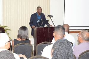
Officially welcoming the company to Guyana was Minister of Public Infrastructure, David Patterson, who immediately seized the opportunity to underscore the importance of entrepreneurship steered by females. Noting that Guyana would have been further advanced had women played a more integral role in business, the Minister lauded Ms. Grant’s persistence and stressed the need for Guyanese women to follow suit.
Relative to the company’s role in Guyana, Patterson explained that modernisation has forced all ministries within Guyana to recognise the importance of geographic information systems (GIS); consequently, the services provided by GeoTechVision are highly anticipated.
The minister further related that several initiatives which the ministry has expressed intention to pursue have already been discussed with Ms. Grant.
Additionally, a task force which is currently being created by the Infrastructure Ministry will source GIS services from this company.
To this end, Minister Patterson congratulated the company on its re-launch, and reiterated his vision for a more developed Guyana, aided by companies of this nature.
The spotlight was then shifted to Ms. Grant, managing director of the company, who, capitalising on the opportunity to provide a historical account of the GeoTechVision, detailed the nature of the company. She said the company, which delivers innovative technological solutions designed to overcome challenges, is one which is much needed in Guyana, given that no other company currently provides most, if not all, of the services available.
Geospatial information and intelligence, she said, is one of the critical elements underpinning decision-making in addressing some of the Region’s most enduring challenges, including economic development, environment and resource management, climate change, and environmental and disaster management.
She said it is for this reason that she opted to establish a base in Guyana, which is now regarded as the company’s “second home.”
With much of its work having to do with supporting the development of “shore zone management systems” designed to help monitor and manage the local sea defence structure, the company is currently working along with the Guyana Mangroves Management Project, providing geographical services for the protection and maintenance of Guyana’s sea defence.
Prior to this, the GeoTechVision team had served as a rescue team for Guyana, working in the employ of the Ministry of Public Works a few years ago.
With an almost impossible deadline of three months for the Public Works Ministry to execute a project, the institution opted to source regional services (that of GeoTechVision), which managed to successfully complete the project.
Additionally, the company has also worked with the Guyana Power and Light Company (GPL) on the mapping of its assets as part of a needs assessment exercise.
GeoTechVision, as a Regional company, serves more than just providing technological solutions to highly complex problems. In fact, one of the aims of the company is to assume some amount of responsibility for regional integration, aiding in the development of the Caribbean.
Not limited to GIS services, the company has embarked on two major projects Regionally. The first, launched some time ago in Jamaica, involves development of specially made Geo brand Android-based tablets which serve as part of a classroom management solution for the digitial classroom experience.
The second project involves delivery of an entrepreneur incubator programme, which is one of only 10 incubators selected across the Caribbean to be part of the Accelerate Caribbean Business Incubation Clinic by Infodev (a World Bank Group).
The incubator offers new and start-up business assistance by providing services such as management training and entrepreneurial guidance to grow a company to a successful state.
Now located at Lot 50 Brickdam, GeoTechVision will, through the GeoTechVision Academy, seek to offer institutionalised training programmes for public and private sector persons.
Some products offered by the company are the RTK UAV/Drone Surveys; Trimble solutions; Mobile GPS receivers; branded mobile storage devices; Geo-tablets; and data products.
Services provided by the company include the GeoTechVision Academy; geospatial consultancy and advisory services; GIS technical services; IT services; Geomatic solutions; classroom management solution; and GPS tracking. (Ravin Singh)
*** PHOTOS saved in graphics folder: GIT launch
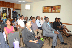
DSC_3857: A section of those in attendance
DSC_3832: Caption:
**DSC 3859