A sedimental journey
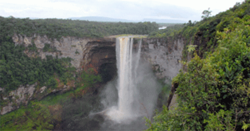
THE name ‘The Roraima Group’ is given the thick sedimentary sequences deposited in the central west of Guyana and forming the Pakaraima Mountains following the Trans-Amazonian upheavals between 2.1 and 1.9 billion years ago. I n geology, the principle of original horizontality is based on observation that sedimentary rocks, namely rocks formed from particles of sand, pebbles and other fragments of material, are deposited in horizontal layers.
The principle of superposition states that sedimentary rocks become younger from bottom to top (unless tectonic forces such as compression have not turned them upside down). This is because younger layers of sediment always accumulate on top of older layers.
In a sequence of sedimentary beds, the oldest bed is the lowest, and the youngest is on top. A body of rock is commonly given a formal name, and referred to as a formation.
A formation can consist of a single rock type, or several different rock types, being distinctive enough in appearance so that a geologic mapper can tell it apart from the surrounding rock layers.
Formations are lumped together into larger rock units called groups, the group comprising two or more formations. The Roraima rocks /Pakaraima Mountains are classified as the Roraima Group because the geological unit comprises two rock formations: Sedimentary rocks (sandstone and conglomerates) and volcanic jasperoid rocks. The layers of rocks identified by geologists tell a story about the origins and development of the present landforms of this geologic unit, including its turbulent volcanic past.
As reported before, the Roraima Group, comprising the Pakaraima Mountains, represents sedimentary fill in a shallow oceanic basin (the Roraima Basin), with material that was derived from erosion of the mountains to the north and north east, formed during the Trans-Amazonian orogeny, some 1.98 billion years ago, a geological process which took millions of years.
In observations on layers of sedimentary rocks of the mountains of the Roraima Group, a geologist named Keats (1974) identified and defined nine layers/depositional units. He named these units, from the oldest to the youngest (and the lowest to the highest), as Units I, II, III, IV etc to Unit IX. (Gibbs and Barron, 1993)
By following each unit, he showed the changes in the paleo-environment of the Roraima Group during the Proterozoic period, between 1.6 and 1.98 billion years ago.
Then, by considering the changes from unit to unit, he showed how source elevation and location and basin filling led to the Roraima Basin being filled up as all the rocks around got eroded and/or down-faulted, and then changing with time from a Basin to the massive Pakaraimas.
Keats (1974) reported that Unit I rock, the oldest layer/ bottommost layer, is found at the foot of the north-east facing escarpment of the Pakaraima Mountains. This layer can be seen today at Makreba Falls along the Kurupung River.
This layer of rock tells a story about the effects of limited fluvial (river) transportation of sediments under generally high-flow regimes, ie, a braided river or nearby fluvio-deltaic depositional environment; ie, the beginnings of the depositions of sediments from the mountains of the Trans-Amazonian orogenic belt to the north east of the group.
Units I to VI rocks are considered the lower strata of the tabular sandstone mountains of the Pakaraimas.
Unit II, it is said, represents “sudden widespread influxes of coarse, poorly-sorted, immature debris brought down from a proximal area (the mountains to the north and north east) in flood conditions.” (Keats 1974)
The unit’s thicknesses vary from 25 to 360 metres.
The units are sometimes conformable, ie, formed without interruption of the depositional process, and sometimes disconformable, a disconformity representing an interruption in deposition of sediments for a period of time before it restarts.
Units VII to IX are the middle member layers.
With respect to unit IX, sandstone and conglomeratic sedimentation in this unit were similar to that of Unit VIII, with the addition of volcanic intercalations (new structures) in the already formed unit.
This took the form of jasper-like vitric tuff falls (tuffs being sedimentary rocks formed by the accumulation of volcanic ashes).
In the Kato-Orinduik area, the tuffaceous jaspers (jasper stones) are usually dark red, with local variations to greenish grey.
In their book, ‘Geology of the Guiana Shield’, Gibbs and Barron (1993) disclosed that a tentative environmental history of the origins and development of the rugged Pakaraima plateaus, which rise up to 2000 and 3000 feet above sea level, has been worked out by Keats (1974) as follows:
After the last Trans-Amazonian orogenic movements of the Guiana Shield, uplift of a source somewhere to the east-north-east initiated the deposition of fluvial deposits in a subsiding foreland (the Roraima Basin). Further uplift led to the deposition of the extensive quartz conglomerates of Unit IV.
Increased subsidence (sinking) of the basin led to further and finer sediments, culminating with those of Unit VI.
A further probably epeirogenic rejuvenation (depression), with some exposure and erosion of the earlier deposits led to the deposition of another wide expanse of conglomerates – Unit VII.
With increasing balance of source uplift and basin subsidence, sedimentation stabilized with deposition of increasingly finer–grained sandstones again.
Intense volcanic activity that occurred at the time in Brazil led to pyroclastic and derived intercalations (clouds of ash and fragments of lava) in Unit IX, but did not appreciatively affect the sedimentation occurring in the Roraima Basin.
Another Unit of the Roraima Group/Pakaraima Mountains, Unit X, has been identified as upper Roraima sediments, but has not been examined more than cursorily in Guyana. (Gibbs and Barron, 1993)
Widespread intrusions by the Avanavero Suite of dikes and sills followed, the hard flat sills giving the Pakaraimas their table-top like appearance.
It must be noted that the alluvial gold and diamonds found in many areas located at the foot of the Pakaraima Mountains, such as in Kurupung, Enachu and Eping, are derived from the erosion of the basal conglomerates at the base of Unit IV.
Those gold and diamonds found in Kamarang and Imbaimadai are derived from the erosion of basal conglomerates at the base of Unit VII.
These conglomerates represent old river channels where gold and diamonds were concentrated and are now eroded.
(Earth Matters is made possible through the ongoing support of local geologists who are knowledgeable about the land forms of Guyana and the processes that shaped them.)
Earth matters…
SHARE THIS ARTICLE :
Facebook
Twitter
WhatsApp


.jpg)


